 |
| From the CairObserver |
Sunday, December 18, 2011


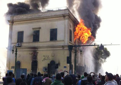
Ancient World Bloggers Group (AWBG): The Fire at the Institut d'Egypte Cairo
Ancient World Bloggers Group (AWBG): The Fire at the Institut d'Egypte Cairo: This is an attempt to pull together (outside the Facebook, Twitter, etc. firewalls) the various pieces of infomation available onl...
Monday, December 12, 2011

Saturday, December 10, 2011
Weekend Archaeology Pics
It's the weekend so I thought I'd share a picture or two from a site I worked on in Southwestern Pennsylvania.
The first photo is of the field crew troweling down the floor of the main excavation block in order to get a "clean" surface examine for any possible prehistoric features. The archaeologist's trowel is sharpened, like a knife, in order to cut the soil. If it were dull, the delicate soil layers would smear together.


In this photograph you can see two more members of the Mon/Yough Chapter #3 analyzing artifacts in our lab located in the Monongahela River, Railroad, and Steam Museum in Brownsville, PA. Don Rados and Jim Barno are analyzing each individual flake from the site above. We recovered more that 8,000 Native American artifacts and flakes from their tool production.


Thursday, December 8, 2011
Establishing a Site Grid
Hello Everyone,
A question that I often get when people stop by and visit a site that I'm excavating is, "Why do you dig square holes?" I'll look around the site for a minute, observing all of the different squares in various forms of excavation and think to myself about how much archaeology is art, well designed art that is. "Imagine yourself standing on a giant sheet of graph paper", I explain.
So I will explain to the rest of you as well! In order that we know exactly where every artifact comes from when we excavate, it is important to keep control by strictly recording their position in the ground. Before an archaeological excavation, the most important tool in the archaeologist's tool box isn't a trowel or shovel, it is the datum point. The datum point is simply the starting point for the grid that will be laid out over the site, using a series of nails and string, to help us keep track of where those artifacts came from.
The datum point is arbitrary, we are archaeologist place it where we think we will get the most squares to excavate to cover a site. Often times, we use some type of survey equipment and a known point, say on the corner of something that isn't going to move, like a bridge, or USGS (United States Geologic Survey) Benchmark point and triangulate it into our site datum.
Once the site datum is established, I like to pound in a wooden stake or piece of metal re-bar, an archaeologist can start to think about his grid. Here in the US, we use the metric system for prehistoric sites, and the Imperial for historic sites (people build their houses and buildings here using feet and inches). The smallest square we can have for grid during a site excavation is 1-meter. I like to use the 2-meter square. So lets try to make a grid for a hypothetical site.
1) Establish a datum and give it a number denoting an X and Y axis.We are going to work in Northings and Eastings. So our datum will be, North 100 E100 represented as N100 E100.
2) On my grid, I use the South West corner of each square as the Unit Datum.
3) That means the next unit to the east is N100 E102 (Remember we are working in 2-meter units)
4) If we move north on our grid, it would be N102 E102
5) If we move south on our grid it would be S102 E102
Here is an example of a grid that we might use:


A question that I often get when people stop by and visit a site that I'm excavating is, "Why do you dig square holes?" I'll look around the site for a minute, observing all of the different squares in various forms of excavation and think to myself about how much archaeology is art, well designed art that is. "Imagine yourself standing on a giant sheet of graph paper", I explain.
So I will explain to the rest of you as well! In order that we know exactly where every artifact comes from when we excavate, it is important to keep control by strictly recording their position in the ground. Before an archaeological excavation, the most important tool in the archaeologist's tool box isn't a trowel or shovel, it is the datum point. The datum point is simply the starting point for the grid that will be laid out over the site, using a series of nails and string, to help us keep track of where those artifacts came from.
The datum point is arbitrary, we are archaeologist place it where we think we will get the most squares to excavate to cover a site. Often times, we use some type of survey equipment and a known point, say on the corner of something that isn't going to move, like a bridge, or USGS (United States Geologic Survey) Benchmark point and triangulate it into our site datum.
Once the site datum is established, I like to pound in a wooden stake or piece of metal re-bar, an archaeologist can start to think about his grid. Here in the US, we use the metric system for prehistoric sites, and the Imperial for historic sites (people build their houses and buildings here using feet and inches). The smallest square we can have for grid during a site excavation is 1-meter. I like to use the 2-meter square. So lets try to make a grid for a hypothetical site.
1) Establish a datum and give it a number denoting an X and Y axis.We are going to work in Northings and Eastings. So our datum will be, North 100 E100 represented as N100 E100.
2) On my grid, I use the South West corner of each square as the Unit Datum.
3) That means the next unit to the east is N100 E102 (Remember we are working in 2-meter units)
4) If we move north on our grid, it would be N102 E102
5) If we move south on our grid it would be S102 E102
Here is an example of a grid that we might use:

So that was a quick lesson on setting up a grid for excavation! On a final not, we use large nails for the four corners of each square and attach string around it to make a neat square and as a digging guide. Here is an example showing surveyors pins marking the corners of a excavation test unit:

Have a great day folks!
Wednesday, December 7, 2011
Archaeo-Porn of the Day
Today I've decided to post some pictures of the excavations that I conducted for my dissertation research in Brownsville, PA. These few pictures are from a house site and show the remnants of
the foundation of this once prominent residence. I've called this the Michael A. Cox House. He was a very prominent steamboat captain, banker, and investor in the small town of Brownsville in the last quarter of the Nineteenth Century.


Sunday, November 20, 2011
Some free tools for Archaeologists
Hello Everyone,
I have recently been noticing on the social network channels (Google+, Facebook, Twitter) a lot of people integrating the Ipad and its software suite for many applications for archaeologists. I cannot agree more that this piece of hardware could be VERY useful in the field. It might even be more so, once a Topcon Total Station can be integrated (if it's not already possible).
However, not every archaeologist or archaeology club has the resources to go out an buy an Ipad or a smart phone for that matter. Not many individuals have the $1,000 for Photoshop or Illustrator, let alone for the expense of Autodesk CAD or Arcview GIS. What about us little archaeology guys and gals who want functionality on the cheap for digitizing maps or using a GIS (Graphic Information Systems) program to help us out? This is your day! I'm going to lay a few great programs for those of us on a budget.
Operating Systems:
Ubuntu Linux- A great open sourced operating system that combines the simplicity of using apps like an Ipad and the stability of Apple. Of special note is the way a user installs and uninstalls applications. Ubuntu has an app store with hundreds of free open sourced programs that are simply installed and uninstalled like an app for Android or IOS. Many of the programs I'll talk about are in that app store for free! Plus its easy to use Unity interface is clean and streamlined. The whole operating system can be downloaded and installed onto a thumb drive and placed on a netbook.
http://www.ubuntu.com/
AROS- A lightweight fast operating system based on the Amiga OS. It is clean, fast, and has a great user support community. This operating system is for those of you who just need a dependable, fast OS for web surfing and using Google Docks for most of your work. Right now there are a limited number of ports for AROS on the research end of things, however, if you have an old machine that cannot run Windows Vista, or Windows 7, AROS can breathe some new life into it!
It's perfect for an archaeologist on a very tight budget looking for a web machine for researching projectile points!
http://aros.sourceforge.net/
Drawing Programs:
 Inkscape- A free vector graphics drawing program.This program is like iDraw only free, and you don't need a Mac or Ipad to use it. This program has a great feature set, and is an excellent replacement for Adobe Illustrator. It will import files directly from Auto CAD (.dxf files), pdfs, Corel, Word Perfect, the list goes on! This program is great for digitizing field maps, plan views, feature profiles, etc. I've posted an image here of a feature I drew. (Mac, Windows, Linux)
http://inkscape.org
Paint.NET- A free drawing program with many of the great feature of Adobe Photoshop without the cost. Is this Photoshop? Well, no. It is not going have feature for feature what Photoshop has, but for the archaeologist on a budget, it does amazing work. There are layers and layer controls and the ability to save in a variety of Tiff, Jpeg, and Png files. There is also an incredible library of plugins to extend Paint.NET's capability. If you are looking for something that has many of the great features of Photoshop, this program is easy to use, and easy to navigate, and expandable. (Windows only!)
http://www.getpaint.net/
GIS: Graphic Information Systems
Grass GIS - This is a powerful system and fully capable to today's standards for GIS applications. Grass works with 2d and 3d maps and images. Grass GIS has been in development for over 20 years and used throughout the government and its agencies for spatial analysis. This software is compatible with Arcview GIS formats. (Windows, Linux, Mac)
http://grass.osgeo.org/
QGIS (Quantum GIS)- a GIS system with an easy to use graphical user interface. As my friend Matt pointed out on Google+, QGIS' "strengths are in its graphical orientation were as GRASS is better at analysis and processing". QGIS can run inside or a GRASS shell bring extended features into the QGIS system. (Windows, Linux, Mac)
http://www.qgis.org/
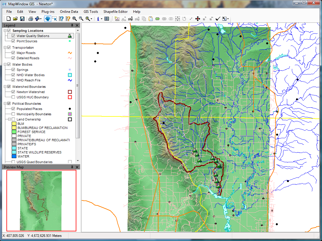
MapWindow GIS- Is a windows specific program and another full featured GIS system. The developers constantly revise and update the software adding more features and stability. It has many features that make the software package impressive and easy to use. (Windows)
http://www.mapwindow.org/
SAGA (System for Automated Geoscientific Analyses)- This one is new to me. I learned about it a short time ago and decided to check it out.
It seems as though SAGA is packed with features as well, and can load many of the Esri files. I have not used this program other than explored some o its features, but again its free. SAGA touts itself as a "user friendly" application, judging by its interface, I would say that it is. Check it out, its a small file size, so don't be afraid to give it a try! (Windows, Linux)
http://www.saga-gis.org/en/index.html
Computer Aided Drafting
LibreCAD- A small lightwieght 2d CAD program that has finally made it 1.0! It's small, compact, and easy to use. It has a few features missing that AutoCAD has, but then LibreCAD isn't a AutoCAD replacement. I use to to plot out excavation grids, test units, and shovel tests. I save those as DXF files and import them into Inkscape for further processing. Sure maybe AutoCAD can do everything I want, but why pay thousands of dollars for it when i can use free programs to get the same job done?
http://librecad.org/cms/home.html
Office Suite
LibreOffice- I've used OpenOffice for years, but switched when Oracle bought the code. LibreOffice is a Microsft Office replacement. It is also Free! LibreOffice can open, save, export, to all Microsoft document files, and it uses the Open Document Text and all Open Document file types. LibreOffice includes a Word (Writer) Power Point (Impress), Access (Base) , Excel (Calc), replacement and even a drawing program! I have typed many site reports, research papers, and made countless power Point presentations to use while teaching classes with LibreOffice. Please it is worth a look, and its Free!
http://www.libreoffice.org/
These are just some of the programs out there that can take the place of, or supplement the existing programs offered by large corporations. Many of the developers of these programs I've listed here represent non-profit foundations, or the hard work of individuals. As always, if a free program makes you money, please give a little back to these organizations that made the choice not to sell their programs. Archaeology can be fun and expensive, hopefully some of these programs can help bring down the cost and add a layer of additional analysis to your projects!

I have recently been noticing on the social network channels (Google+, Facebook, Twitter) a lot of people integrating the Ipad and its software suite for many applications for archaeologists. I cannot agree more that this piece of hardware could be VERY useful in the field. It might even be more so, once a Topcon Total Station can be integrated (if it's not already possible).
However, not every archaeologist or archaeology club has the resources to go out an buy an Ipad or a smart phone for that matter. Not many individuals have the $1,000 for Photoshop or Illustrator, let alone for the expense of Autodesk CAD or Arcview GIS. What about us little archaeology guys and gals who want functionality on the cheap for digitizing maps or using a GIS (Graphic Information Systems) program to help us out? This is your day! I'm going to lay a few great programs for those of us on a budget.
Operating Systems:
 |
| Image via Wikipedia |
http://www.ubuntu.com/
 |
| Image via Wikipedia |
It's perfect for an archaeologist on a very tight budget looking for a web machine for researching projectile points!
http://aros.sourceforge.net/
Drawing Programs:
 |
| Wikipedia |
 Inkscape- A free vector graphics drawing program.This program is like iDraw only free, and you don't need a Mac or Ipad to use it. This program has a great feature set, and is an excellent replacement for Adobe Illustrator. It will import files directly from Auto CAD (.dxf files), pdfs, Corel, Word Perfect, the list goes on! This program is great for digitizing field maps, plan views, feature profiles, etc. I've posted an image here of a feature I drew. (Mac, Windows, Linux)
http://inkscape.org
 |
| Wikipedia |
http://www.getpaint.net/
GIS: Graphic Information Systems
 |
| Image via Wikipedia |
Grass GIS - This is a powerful system and fully capable to today's standards for GIS applications. Grass works with 2d and 3d maps and images. Grass GIS has been in development for over 20 years and used throughout the government and its agencies for spatial analysis. This software is compatible with Arcview GIS formats. (Windows, Linux, Mac)
http://grass.osgeo.org/
 |
| Wikipedia |
http://www.qgis.org/
 |
| Wikipedia |
http://www.mapwindow.org/
 |
| Wikipedia |
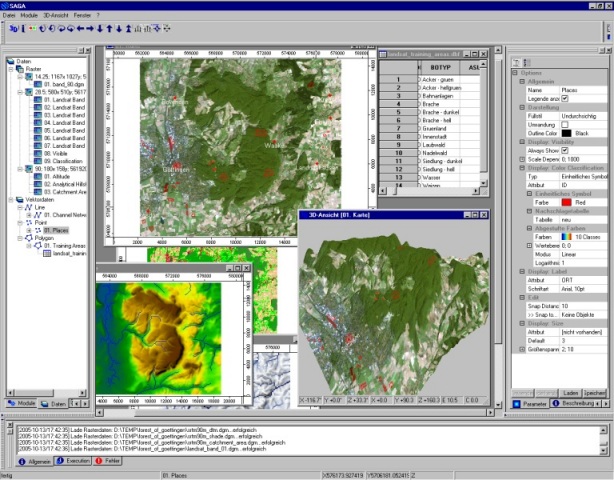
It seems as though SAGA is packed with features as well, and can load many of the Esri files. I have not used this program other than explored some o its features, but again its free. SAGA touts itself as a "user friendly" application, judging by its interface, I would say that it is. Check it out, its a small file size, so don't be afraid to give it a try! (Windows, Linux)
http://www.saga-gis.org/en/index.html
Computer Aided Drafting

 |
| Wikipedia |
http://librecad.org/cms/home.html
Office Suite

 |
| Wikipedia |
http://www.libreoffice.org/
These are just some of the programs out there that can take the place of, or supplement the existing programs offered by large corporations. Many of the developers of these programs I've listed here represent non-profit foundations, or the hard work of individuals. As always, if a free program makes you money, please give a little back to these organizations that made the choice not to sell their programs. Archaeology can be fun and expensive, hopefully some of these programs can help bring down the cost and add a layer of additional analysis to your projects!
Subscribe to:
Posts (Atom)