Hello Everyone,
Archaeologists have known for decades that some native groups practiced skull deformation. I guess the "Alien-Like" is something to grab the attention of readers. Very cool discovery!
'Alien-like' skulls are unearthed in 1,000-year-old cemetery
Showing posts with label Archaeological site. Show all posts
Showing posts with label Archaeological site. Show all posts
Friday, December 21, 2012


Tuesday, July 10, 2012
Some Post Excavation Thoughts: Snowdon Vulcan Iron and Machine Works
Hello Everyone,
Things have been busy for me this past month, so I haven't had time for an update. The John Snowdon and Son's Vulcan Iron and Machine Works excavations in Brownsville, Pennsylvania have come to a close for this field season. I cannot thank the volunteers enough and the students from the WVU Field School who came out to pick through some of the toughest fill material I have ever encountered. We have recovered an incredible amount of data dating back to the turn of the 20th-century. Personal items, industrial artifacts, and a variety of little unidentified items that will keep us busy for a long time. However, we also have the most important artifact, the foundry itself, a mausoleum to 19th-century industrialization in the Monongahela River Valley. It is my estimate that we have excavated 5% of the total structure. We haven't even begun to excavate within its interior except along the foundation walls.
In the first three photographs show an air pocket that we hit during excavation. Within it are the remains of a barrel laying on its side. The strapping is just visible to the left of that concrete floor joist support. When the building was demolished by the railroad, the area next to that floor joist created an air gap with brick from an interior wall. No artifacts were found with the barrel that would indicate its contents. the final picture is Erin who came out do some mapping of our foundations!
 |
| Air gap with barrel strapping. |
 |
| Close-up of the barrel remains. |
 |
| The Completed excavation unit with exterior wall to south. Barrel removed. |
 |
| Erin field mapping in the shade! |

Wednesday, June 6, 2012
Snowdown and Sons: Field Pictures.
Hello Everyone,
Things have been running on overdrive at the Snowdon Site! We are in the process of completing our first field season there at the end of this week, although it looks like we may be there next week as well. We've made a startling discovery as well, that I will elaborate on in my next post. For now, here are some great photos of this past week's field work. Enjoy!
Things have been running on overdrive at the Snowdon Site! We are in the process of completing our first field season there at the end of this week, although it looks like we may be there next week as well. We've made a startling discovery as well, that I will elaborate on in my next post. For now, here are some great photos of this past week's field work. Enjoy!
 |
| Julz and Kyle |
 |
| Outside North Foundation Wall |
 |
| N116-120 E100-108 Excavation Block |
 |
| Volunteer Chaze Excavating around the remains of puddled iron |
 |
| Kyle holding the remains of a leather sack! (We also have the contents!) |
 |
| Carl Mapping a portion of the exterior North Foundation. |
Monday, May 21, 2012
Snowdon Foundry Weekend Work Day 7-8.
Hello Everyone,
Updates didn't occur these past couple of days due to a lack of Internet service. Anyhow, I'm back to report on this weekend's activity at the Snowdon and Sons Vulcan Iron and Machine Works. This weekend was the Market Street Arts Festival in downtown Brownsville, Pennsylvania. Like last year, this is a time when we coordinate Brownsville Archaeology Month to coincide with the festival. After all, isn't archaeology an art? Sure it is, we paint and sculpt the past as well as any artist! So to say the least, we had quite a few visitors to our site to check it out. Although we have been excavating for over two weeks, we still have yet to see any Brownsville Council person, the mayor, or any Brownsville Historical Society official at the site, let alone anyone from the Fayette County Historical Society. A shame really, as these are the people who we expect to advocates for the town, but really only care about the limited world views that they have. Anyhow, here are the pics from the weekend!
Updates didn't occur these past couple of days due to a lack of Internet service. Anyhow, I'm back to report on this weekend's activity at the Snowdon and Sons Vulcan Iron and Machine Works. This weekend was the Market Street Arts Festival in downtown Brownsville, Pennsylvania. Like last year, this is a time when we coordinate Brownsville Archaeology Month to coincide with the festival. After all, isn't archaeology an art? Sure it is, we paint and sculpt the past as well as any artist! So to say the least, we had quite a few visitors to our site to check it out. Although we have been excavating for over two weeks, we still have yet to see any Brownsville Council person, the mayor, or any Brownsville Historical Society official at the site, let alone anyone from the Fayette County Historical Society. A shame really, as these are the people who we expect to advocates for the town, but really only care about the limited world views that they have. Anyhow, here are the pics from the weekend!
 |
| Pattern Shop Wall |
 |
| Pattern Shop Wall Excavation Block with Security Fence |
 |
| The Pattern Shop Foundation extends 6 feet below ground surface |
 |
| Interior Pattern Shop Excavation Block |
 |
| Liz taking elevations |
 |
| Left to right: Jonathan Crise, Kyle Norman, and Marc Henshaw (Archaeology Dude) |
Thursday, December 8, 2011
Establishing a Site Grid
Hello Everyone,
A question that I often get when people stop by and visit a site that I'm excavating is, "Why do you dig square holes?" I'll look around the site for a minute, observing all of the different squares in various forms of excavation and think to myself about how much archaeology is art, well designed art that is. "Imagine yourself standing on a giant sheet of graph paper", I explain.
So I will explain to the rest of you as well! In order that we know exactly where every artifact comes from when we excavate, it is important to keep control by strictly recording their position in the ground. Before an archaeological excavation, the most important tool in the archaeologist's tool box isn't a trowel or shovel, it is the datum point. The datum point is simply the starting point for the grid that will be laid out over the site, using a series of nails and string, to help us keep track of where those artifacts came from.
The datum point is arbitrary, we are archaeologist place it where we think we will get the most squares to excavate to cover a site. Often times, we use some type of survey equipment and a known point, say on the corner of something that isn't going to move, like a bridge, or USGS (United States Geologic Survey) Benchmark point and triangulate it into our site datum.
Once the site datum is established, I like to pound in a wooden stake or piece of metal re-bar, an archaeologist can start to think about his grid. Here in the US, we use the metric system for prehistoric sites, and the Imperial for historic sites (people build their houses and buildings here using feet and inches). The smallest square we can have for grid during a site excavation is 1-meter. I like to use the 2-meter square. So lets try to make a grid for a hypothetical site.
1) Establish a datum and give it a number denoting an X and Y axis.We are going to work in Northings and Eastings. So our datum will be, North 100 E100 represented as N100 E100.
2) On my grid, I use the South West corner of each square as the Unit Datum.
3) That means the next unit to the east is N100 E102 (Remember we are working in 2-meter units)
4) If we move north on our grid, it would be N102 E102
5) If we move south on our grid it would be S102 E102
Here is an example of a grid that we might use:


A question that I often get when people stop by and visit a site that I'm excavating is, "Why do you dig square holes?" I'll look around the site for a minute, observing all of the different squares in various forms of excavation and think to myself about how much archaeology is art, well designed art that is. "Imagine yourself standing on a giant sheet of graph paper", I explain.
So I will explain to the rest of you as well! In order that we know exactly where every artifact comes from when we excavate, it is important to keep control by strictly recording their position in the ground. Before an archaeological excavation, the most important tool in the archaeologist's tool box isn't a trowel or shovel, it is the datum point. The datum point is simply the starting point for the grid that will be laid out over the site, using a series of nails and string, to help us keep track of where those artifacts came from.
The datum point is arbitrary, we are archaeologist place it where we think we will get the most squares to excavate to cover a site. Often times, we use some type of survey equipment and a known point, say on the corner of something that isn't going to move, like a bridge, or USGS (United States Geologic Survey) Benchmark point and triangulate it into our site datum.
Once the site datum is established, I like to pound in a wooden stake or piece of metal re-bar, an archaeologist can start to think about his grid. Here in the US, we use the metric system for prehistoric sites, and the Imperial for historic sites (people build their houses and buildings here using feet and inches). The smallest square we can have for grid during a site excavation is 1-meter. I like to use the 2-meter square. So lets try to make a grid for a hypothetical site.
1) Establish a datum and give it a number denoting an X and Y axis.We are going to work in Northings and Eastings. So our datum will be, North 100 E100 represented as N100 E100.
2) On my grid, I use the South West corner of each square as the Unit Datum.
3) That means the next unit to the east is N100 E102 (Remember we are working in 2-meter units)
4) If we move north on our grid, it would be N102 E102
5) If we move south on our grid it would be S102 E102
Here is an example of a grid that we might use:

So that was a quick lesson on setting up a grid for excavation! On a final not, we use large nails for the four corners of each square and attach string around it to make a neat square and as a digging guide. Here is an example showing surveyors pins marking the corners of a excavation test unit:

Have a great day folks!
Sunday, November 20, 2011
Some free tools for Archaeologists
Hello Everyone,
I have recently been noticing on the social network channels (Google+, Facebook, Twitter) a lot of people integrating the Ipad and its software suite for many applications for archaeologists. I cannot agree more that this piece of hardware could be VERY useful in the field. It might even be more so, once a Topcon Total Station can be integrated (if it's not already possible).
However, not every archaeologist or archaeology club has the resources to go out an buy an Ipad or a smart phone for that matter. Not many individuals have the $1,000 for Photoshop or Illustrator, let alone for the expense of Autodesk CAD or Arcview GIS. What about us little archaeology guys and gals who want functionality on the cheap for digitizing maps or using a GIS (Graphic Information Systems) program to help us out? This is your day! I'm going to lay a few great programs for those of us on a budget.
Operating Systems:
Ubuntu Linux- A great open sourced operating system that combines the simplicity of using apps like an Ipad and the stability of Apple. Of special note is the way a user installs and uninstalls applications. Ubuntu has an app store with hundreds of free open sourced programs that are simply installed and uninstalled like an app for Android or IOS. Many of the programs I'll talk about are in that app store for free! Plus its easy to use Unity interface is clean and streamlined. The whole operating system can be downloaded and installed onto a thumb drive and placed on a netbook.
http://www.ubuntu.com/
AROS- A lightweight fast operating system based on the Amiga OS. It is clean, fast, and has a great user support community. This operating system is for those of you who just need a dependable, fast OS for web surfing and using Google Docks for most of your work. Right now there are a limited number of ports for AROS on the research end of things, however, if you have an old machine that cannot run Windows Vista, or Windows 7, AROS can breathe some new life into it!
It's perfect for an archaeologist on a very tight budget looking for a web machine for researching projectile points!
http://aros.sourceforge.net/
Drawing Programs:
 Inkscape- A free vector graphics drawing program.This program is like iDraw only free, and you don't need a Mac or Ipad to use it. This program has a great feature set, and is an excellent replacement for Adobe Illustrator. It will import files directly from Auto CAD (.dxf files), pdfs, Corel, Word Perfect, the list goes on! This program is great for digitizing field maps, plan views, feature profiles, etc. I've posted an image here of a feature I drew. (Mac, Windows, Linux)
http://inkscape.org
Paint.NET- A free drawing program with many of the great feature of Adobe Photoshop without the cost. Is this Photoshop? Well, no. It is not going have feature for feature what Photoshop has, but for the archaeologist on a budget, it does amazing work. There are layers and layer controls and the ability to save in a variety of Tiff, Jpeg, and Png files. There is also an incredible library of plugins to extend Paint.NET's capability. If you are looking for something that has many of the great features of Photoshop, this program is easy to use, and easy to navigate, and expandable. (Windows only!)
http://www.getpaint.net/
GIS: Graphic Information Systems
Grass GIS - This is a powerful system and fully capable to today's standards for GIS applications. Grass works with 2d and 3d maps and images. Grass GIS has been in development for over 20 years and used throughout the government and its agencies for spatial analysis. This software is compatible with Arcview GIS formats. (Windows, Linux, Mac)
http://grass.osgeo.org/
QGIS (Quantum GIS)- a GIS system with an easy to use graphical user interface. As my friend Matt pointed out on Google+, QGIS' "strengths are in its graphical orientation were as GRASS is better at analysis and processing". QGIS can run inside or a GRASS shell bring extended features into the QGIS system. (Windows, Linux, Mac)
http://www.qgis.org/
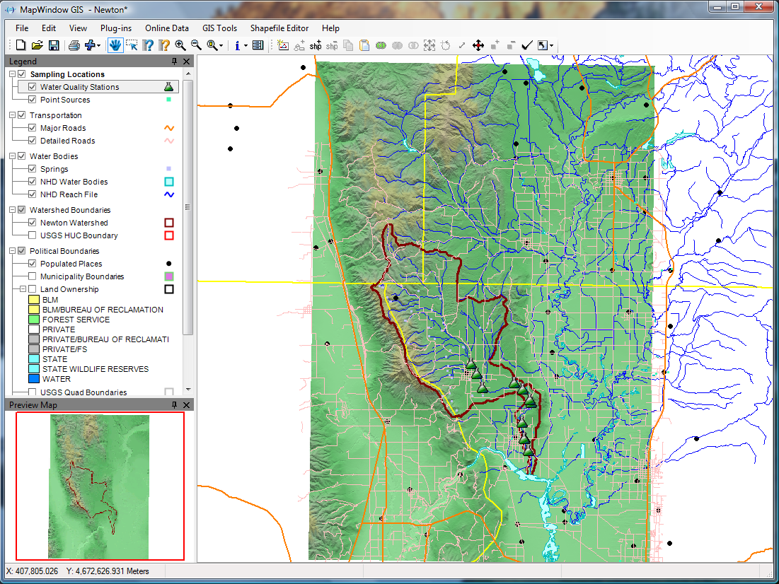
MapWindow GIS- Is a windows specific program and another full featured GIS system. The developers constantly revise and update the software adding more features and stability. It has many features that make the software package impressive and easy to use. (Windows)
http://www.mapwindow.org/
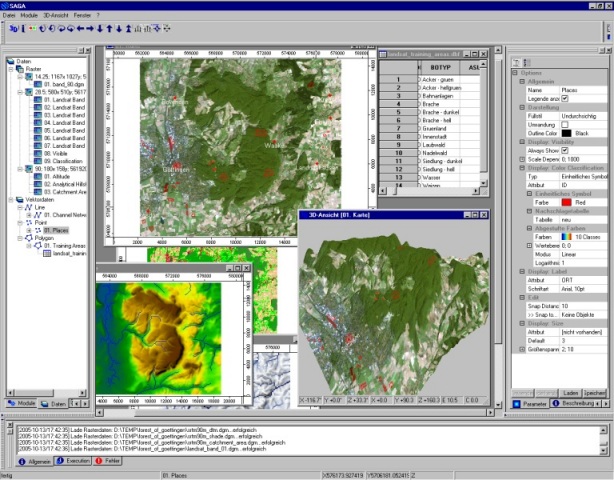
SAGA (System for Automated Geoscientific Analyses)- This one is new to me. I learned about it a short time ago and decided to check it out.
It seems as though SAGA is packed with features as well, and can load many of the Esri files. I have not used this program other than explored some o its features, but again its free. SAGA touts itself as a "user friendly" application, judging by its interface, I would say that it is. Check it out, its a small file size, so don't be afraid to give it a try! (Windows, Linux)
http://www.saga-gis.org/en/index.html
Computer Aided Drafting
LibreCAD- A small lightwieght 2d CAD program that has finally made it 1.0! It's small, compact, and easy to use. It has a few features missing that AutoCAD has, but then LibreCAD isn't a AutoCAD replacement. I use to to plot out excavation grids, test units, and shovel tests. I save those as DXF files and import them into Inkscape for further processing. Sure maybe AutoCAD can do everything I want, but why pay thousands of dollars for it when i can use free programs to get the same job done?
http://librecad.org/cms/home.html
Office Suite
LibreOffice- I've used OpenOffice for years, but switched when Oracle bought the code. LibreOffice is a Microsft Office replacement. It is also Free! LibreOffice can open, save, export, to all Microsoft document files, and it uses the Open Document Text and all Open Document file types. LibreOffice includes a Word (Writer) Power Point (Impress), Access (Base) , Excel (Calc), replacement and even a drawing program! I have typed many site reports, research papers, and made countless power Point presentations to use while teaching classes with LibreOffice. Please it is worth a look, and its Free!
http://www.libreoffice.org/
These are just some of the programs out there that can take the place of, or supplement the existing programs offered by large corporations. Many of the developers of these programs I've listed here represent non-profit foundations, or the hard work of individuals. As always, if a free program makes you money, please give a little back to these organizations that made the choice not to sell their programs. Archaeology can be fun and expensive, hopefully some of these programs can help bring down the cost and add a layer of additional analysis to your projects!

I have recently been noticing on the social network channels (Google+, Facebook, Twitter) a lot of people integrating the Ipad and its software suite for many applications for archaeologists. I cannot agree more that this piece of hardware could be VERY useful in the field. It might even be more so, once a Topcon Total Station can be integrated (if it's not already possible).
However, not every archaeologist or archaeology club has the resources to go out an buy an Ipad or a smart phone for that matter. Not many individuals have the $1,000 for Photoshop or Illustrator, let alone for the expense of Autodesk CAD or Arcview GIS. What about us little archaeology guys and gals who want functionality on the cheap for digitizing maps or using a GIS (Graphic Information Systems) program to help us out? This is your day! I'm going to lay a few great programs for those of us on a budget.
Operating Systems:
 |
| Image via Wikipedia |
http://www.ubuntu.com/
 |
| Image via Wikipedia |
It's perfect for an archaeologist on a very tight budget looking for a web machine for researching projectile points!
http://aros.sourceforge.net/
Drawing Programs:
 |
| Wikipedia |
 Inkscape- A free vector graphics drawing program.This program is like iDraw only free, and you don't need a Mac or Ipad to use it. This program has a great feature set, and is an excellent replacement for Adobe Illustrator. It will import files directly from Auto CAD (.dxf files), pdfs, Corel, Word Perfect, the list goes on! This program is great for digitizing field maps, plan views, feature profiles, etc. I've posted an image here of a feature I drew. (Mac, Windows, Linux)
http://inkscape.org
 |
| Wikipedia |
http://www.getpaint.net/
GIS: Graphic Information Systems
 |
| Image via Wikipedia |
Grass GIS - This is a powerful system and fully capable to today's standards for GIS applications. Grass works with 2d and 3d maps and images. Grass GIS has been in development for over 20 years and used throughout the government and its agencies for spatial analysis. This software is compatible with Arcview GIS formats. (Windows, Linux, Mac)
http://grass.osgeo.org/
 |
| Wikipedia |
http://www.qgis.org/
 |
| Wikipedia |
http://www.mapwindow.org/
 |
| Wikipedia |
It seems as though SAGA is packed with features as well, and can load many of the Esri files. I have not used this program other than explored some o its features, but again its free. SAGA touts itself as a "user friendly" application, judging by its interface, I would say that it is. Check it out, its a small file size, so don't be afraid to give it a try! (Windows, Linux)
http://www.saga-gis.org/en/index.html
Computer Aided Drafting

 |
| Wikipedia |
http://librecad.org/cms/home.html
Office Suite

 |
| Wikipedia |
http://www.libreoffice.org/
These are just some of the programs out there that can take the place of, or supplement the existing programs offered by large corporations. Many of the developers of these programs I've listed here represent non-profit foundations, or the hard work of individuals. As always, if a free program makes you money, please give a little back to these organizations that made the choice not to sell their programs. Archaeology can be fun and expensive, hopefully some of these programs can help bring down the cost and add a layer of additional analysis to your projects!
Monday, October 10, 2011
Archaeology and Gas Well Drilling: A Discussion
I thought I would write a small
commentary on the interview I had with the Observer-Reporter from the
last post. Hopefully this will clear a few things up about how
archaeological sites are impacted by drilling for natural gas. This
will also serve as a rebuttal to Robert McHale of Mark West Liberty
Midstream & Resources. So let's get through this complicated mess
that has become of archaeology in Pennsylvania.
 Image via Wikipedia Image via Wikipedia |
| Extent of Marellus Shale Gas USGS |
Let me add a disclaimer to start. I am
NOT OPPOSED to gas well drilling! We need the energy her in the
United States, and it's always better if we use our own resources
than take it from someone else. What I am concerned with, is the lack
of Phase I archaeological surveys for these Marcellus Shale gas
extraction sites.
Normally when a company wants to build
something, such as a cell phone tower or highway, where state of
federal monies are being used, it trips Section 106 of the National
Historic Preservation Act.This is part of their permitting process.
An archaeological survey must be done to look for sites that are
unknown or possibly known about. We do this by using a map with the
area that will be impacted, and dig test holes screening all of the
material in an ordered grid like pattern. If we find a site,
depending on its size or historical significance, the project can be
moved away from it, or further archaeological testing must be done. I
have worked surveying cell phone towers that are 100 feet by 100
feet, very small in comparison to the acres of disturbance a gas well
can cause.
Unfortunately in Pennsylvania, the
permits are funneled through the Department of Environmental
Protection (DEP) who for some reason, sees only the size of the well
head which is 1 meter by 1 meter in size. They ignore the acres upon
acres that are destroyed by access roads, sediment ponds, and the
preparation of the enormous well pads!
To read that Robert McHale would say
that they “pick a clear spot” and go. A clear spot, in a farmers
field, over looking a stream? A perfect spot for a Native American
village or camp? Mr. McHale would like the readers to believe that
they have access to all of the databases that the state has, and they
probably do, but what about the sites not on the map? Section 106 is
about finding the unrecorded sites, the sites that lay buried just
beneath the soil. There are burials out there, children and infants.
Their bones scattered by the bulldozer because these people think
that they have the answers. I am constantly surprised by the lack of
intervention by Native Americans in this situation that Pennsylvania
has found itself in.
Archaeological sites and data
cannot be put back into place. If the law is good enough for a
company building a cell phone tower or coal mine, it should be good
enough for a resource extraction company. It is estimated that 44,000
wells will be drilled in Pennsylvania alone, that 44,000
archaeological sites impacted if we don't find them and work with the
companies to protect them.

Sunday, October 9, 2011
Gas drilling threatens archaeological sites!
 Image via Wikipedia
An interview with Archaeology Dude (Marc Henshaw)
Image via Wikipedia
An interview with Archaeology Dude (Marc Henshaw)As taken from the Washington, Pennsylvania Observer-Reporter on 10/09/11:
As drilling expands, area archaeologists worry that historical sites will be undone
By
Christie Campbell Staff writer chriscam@observer-reporter.com
But archaeologists are on staff or accessible to local gas drillers and processors, who say the professionals assist in determining optimum places to drill or lay pipeline in order to avoid historical areas.
Because Pennsylvania laws do not require archaeological surveys for sites under 10 acres, natural gas drilling pads, which take up about 4 or 5 acres, are exempt.
That concerns archaeologists like Marc Henshaw, president of the Mon-Yough Chapter of the Society for Pennsylvania Archaeology in Brownsville. Natural gas extraction operations usually encompass multiple sites such as drilling pads, staging areas and water impoundments, and the acreage is not added together.
Henshaw, who also operates a private survey company, has undertaken archaeological studies prior to the construction of roads, shopping centers and cellular towers but has yet to receive a call from a gas extraction company.
That could be because archaeologists are employed by the industry. Mike Mackin, communications manager for Range Resources, said the company's archaeologist combs through state records and databases to determine if an area has significant archaeological importance before determining where to locate a drill site.
"Which would we rather do, stop a pipeline and notify the (Pennsylvania Historical and Museum Commission) or do it on the front end, pick a clear spot, and go?" asked Robert McHale, manager of environmental regulatory affairs for MarkWest Liberty Midstream & Resources. The company has an archaeologist who reviews preliminary pipeline routes. Environmental inspectors can be found on job sites but, noting that pipelines often are going through agricultural lands that have been tilled over many times, McHale said finding something is "on the low end."
But Henshaw fears there may be thousands of archaeological and historical sites that have not been recorded with the PHMC. The chapter has been working on recording sites in Greene County and over a period of 50 years has identified 296 of them.
Speaking for the Marcellus Shale Coalition in Southpointe, Travis Windle said that if an artifact is found, the industry is required to notify the Bureau of Historic Preservation, which has 180 days to complete a site excavation.
Henshaw was part of a survey of a Monongahela People site discovered in 1997 when construction of the Strabane Square shopping center began. The village dated to 1400 A.D., and two burials were found at the site.
Archaeological teams from Indiana University of Pennsylvania studied the site, and developers even relocated two stores in order that the entire site could be left intact. Today, it lies buried under the center's parking lot, thus further preserving it, Henshaw said.
The chapter is not opposed to gas drilling, said Henshaw, but wants it done safely, lawfully and with care to minimize impacts to archaeological sites.
According to Howard Pollman, spokesman with the PHMC, the 10-acre rule is the result of a policy agreement between the commission and the state Department of Environmental Protection when much land across Pennsylvania was being developed in the 1990s.
"People think it's an exemption for Marcellus Shale, and it's not," he said. It does not apply to sites on the National Register of Historic Places or a project receiving federal funds.
Although the PHMC is not a regulatory body, it does make recommendations for property owners wishing to lease their land for gas drilling, advising them to require gas developers to protect historic resources. It also calls on drilling companies to check with local historical societies or a county planning office for maps of known historic sites or cemeteries.
Doug McLearen, PHMC's division chief of archaeology and protection, acknowledged that as the number of Marcellus Shale projects increase, there is a greater probability that a significant site could be impacted.
That possibility concerns history buffs like Carl Maurer, the archaeology society chapter's vice president, whose eyes light up when he talks about digs he's been on. If sites are destroyed, the knowledge and the motivation to learn more could be gone forever, he said.
"In 50 years, students may want access to something, and it won't be there," he said. "We don't even know what we're losing."

Subscribe to:
Posts (Atom)